This is a paper of eyewitness accounts by people who ‘shot’ or otherwise encountered the Falls of the Ohio rapids in the 1700s to the early 1900s. They wrote down their thoughts, feelings, and experiences when encountering this natural obstacle to river navigation.
The idea for this paper came to me in 2014 when 2 Staff at The Filson Historical Society in Louisville, KY, gave a talk on early travelogues in the U.S. I thought about what eyewitness accounts there might be of the Falls rapids and began the research to find out and create this paper of those eyewitness accounts.
This paper is an educational tool for Volunteers at the Falls Park and an item of interest for others who wish to know more about the early history of encountering the Falls.
As the attributions will show, most of the eyewitness accounts come from books, manuscripts, etc., The Filson holds. I’m grateful for the great help and assistance I received from Curator Jim Holmberg and his Library and Special Collections Staff in compiling these eyewitness accounts. The Filson holds an impressive collection of travel accounts, regarding the Falls and many other locations.
This paper quotes extensively from items in the collection of The Filson Historical Society. Any reuse/republication of that cited material should credit The Filson.
Paul Olliges
Louisville, KY
20+ year Volunteer at the Falls of the Ohio Interpretive Center and State Park in Clarksville, IN. fallsoftheohio.org 812-280-8689
7-23-2015
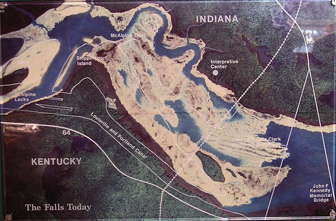
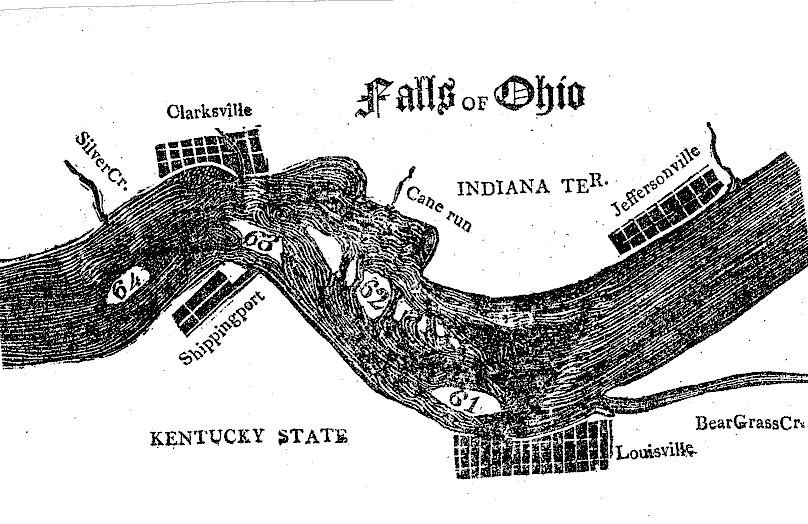
This is the mural on the rotunda wall in the Falls Interpretive Center; it will help when reading some of these accounts. This isn’t taken from any particular map, but is based on early maps of the Falls area before European contact with Native Americans in the Ohio Valley, which occurred in the 17th century.
Introduction:
Leland R. Johnson and Charles E. Parrish, “Triumph at the Falls: The Louisville and Portland Canal”, U.S. Army Corps of Engineers, Louisville District, 2007; Library of Congress Control#: 2005931890. Also available at the US Army Corps of Engineers Digital Library site: http://cdm16021.contentdm.oclc.org/cdm/singleitem/collection/p16021coll4/id/71/rec/1
Page 2:
“Falls of the Ohio was a misnomer, leading strangers to visualize them as precipitous falls with vertical drops like Cumberland Falls or Niagara Falls. People with this misconception often were disappointed when they saw the Falls of the Ohio, because these were better described as rapids, not falls. Although the total descent of the river at the Falls was 26 feet, it dropped through a long stretch of river with no vertical falls higher than 8 feet. Who originated this misnomer is no longer apparent, but they were so named in the first description of them penned in English. In 1742 John Peter Salley with 4 other Virginia explorers floated down the New, Kanawha, and Ohio rivers in a bullboat, a wooden frame covered with buffalo skins, reaching the Falls of the Ohio in May. “The Falls,” Salley reported, “are 3 miles long in which is a small island, the body of the stream running on the north side through which is no passing by reason of great rocks and large whirlpools.” Lacking Indian guides to pilot them over the Falls, Salley and his companions clung near the south bank for safety and descended the rapids south of Corn Island through the shallow chute later called Kentucky chute because it was nearest the south bank and located within the Commonwealth of Kentucky.”
Page 9:
“The original low-water passage between rocks through Indian chute was indeed narrow. George Gretsinger, one of the early Falls pilots, reported the space between the rocks of Indian chute was initially only 11 feet and 8 inches wide. This clearance was adequate for narrow canoes and bateaux [small boats], but not for flatboats, often 15 feet or more abeam. The early Falls pilots therefore carried sledgehammers along during their passages through the chute to knock off the projecting points of rock, and in this primitive fashion they gradually widened the space between rocks to 18 feet. Still, Gretsinger reported, “many flatboats with their cargoes have been injured or lost, coming in contact with rocks.”
Page 16:
Around 1806, a boat owner “…declared that from 8 to 12 boats were wrecked and lost every year while crossing the Falls, and he was grateful that his was not added to that annual destruction. Reasoning from this fragmentary evidence, it appeared that about 1% of the boats crossing the Falls before 1811 were totally wrecked while a larger percentage suffered significant damages. The exact number can never be known because no records of the wrecks were kept; indeed, most were not mentioned in local newspapers until the 1840s when newspapers began employing river reporters. As late as 1874, after some improvements to the Falls chutes had been completed, insurance agents added 1% surcharge for any boat attempting to shoot the Falls after dark.”
============================================================
This starts the eyewitness accounts, in chronological order:
(Years are separated by the long double line; accounts within the same year are separated by a short single line.)
1765, June
George Croghan, “A Selection of George Croghan’s Letters and Journals Relating to Tours in the Western Country….”. From Reuben Gold Thwaites (1853-1913), Editor, “Early Western Travels, 1748-1846”, 32 vols published in 1904-07; Vol 1, pg 136; The Filson Historical Society, call# 917.3 T548:
“We arrived within a mile of the Falls of Ohio…. Early in the [next] morning we embarked, and passed the Falls. The river being very low we were obliged to lighten our boats, and pass on the north side of a little island, which lays in the middle of the river. In general, what is called the Fall here, is no more than rapids; and in the least fresh [low water], a batteau [shallow-draft, flat-bottom boat] of any size may come and go on each side without any risk.”
Editor Thwaites’ footnote:
The above description is “One of the earliest descriptions of the Falls of the Ohio. Gist was ordered to explore as far as there in 1750, but did not reach the goal. Findlay was there in 1753. Gordon gives an account similar to Croghan’s in 1766 [see the year ‘1766’ in this paper]. Ensign Butricke made more of an adventure in passing these falls [see quotes under 1768, August, for more]. … An attempt at a settlement was made by John Connolly (1773); but the beginnings of the present city of Louisville are due to the pioneers who accompanied George Rogers Clark thither in 1778, and made their first home on Corn Island.”
===========================================================
1766
Captain Harry Gordon, “A Journal of a Journey from Pittsburgh Down the Ohio and Mississippi Rivers to New Orleans”, Newton D. Mereness, Editor, “Travels in the American Colonies”, published 1961; pg 467. From Dorothy Rush, “Early Accounts of Travel to the Falls of the Ohio: A Bibliography with selected quotations, 1765-1833”, The Filson Historical Society History Quarterly, Vol. 68, No. 2, April 1994, pg 234:
“Mr. Morgan unloaded one third, and with the Assistance of the Indians, who knew the Channel best, and were useful and willing, got his Boats safe down the Rapid on the North side. The Carrying Place [portage] is ¾ mile on this side and half as much on the SE. This last is Safer for those that are Unacquainted, but more tedious, as during part of the Summer and fall they must drag their Boats over the flat Rock…”
===========================================================
1768, August
Ensign George Butricke, wrote a letter on Sept 15, 1768, to a friend, probably a
military friend, about a trip down the Ohio River. He wrote it from Fort de Chartres, a French fortification first built in 1720 on the east bank of the Mississippi River in present-day Illinois.
From “The Historical Magazine”, Vol. 8, page 259, published in 1864.
You can see the whole letter and others at:
www.mocavo.com/The-Historical-Magazine-Volume-Viii/639782/262
[Spelling, punctuation, & wording are Butrickes.]
“The 8th Aug. we arrived at the Falls, which you’ll see is 682 miles from Fort Pitt, in 20 days. We Reckoned this good going, But I think with 2 or 3 Boats it might be done in half the time. The Falls appear very tremendous at first sight, and startled our people much, as they had not been used to things of this kind before. I made Light of it, and after I had survey’d them well, offered to go down them immediately in my Boat, which made many of them swear that none but a mad man would attempt a thing of the kind. However, this pleased the Colonel so much that he swore there was nothing I ever see that I would not attempt; however, he would not suffer me to go down that night. Next morning sent the Engineer Hutchins to see if a passage could be found in the South shore [Louisville], who return’d at 11 o’clock with the report that it could not be effected. Col. Wilkins came to me again, tould me to be cautious of what I did, that he did not, by any means, desire me to hazard my Life in such a manner But if I really thought it could be done he would give me Leave. I jumpt at the opportunity, threw some Baggage out of the Boat to make her Light in the head, and went off instantly. I Reconitred [reconnoitered] the head of the falls well before I made the attempt, and when I had found the passage went off, and in 2 minutes and 5 seconds pass’d the falls, that are near a Mile in Length, without the Least difficulty. All the people was looking out to see what would be our fate and when the Colonel see I had gott safe down he Come to meet me on my Return to the Camp by Land & gave me his hearty thanks. He then ordered the whole to prepare to pass them, and that night we gott of 8 more, & next day completed the passage.”
===========================================================
1782
These have nothing to do with the Falls directly, but are interesting items I noticed while doing research. All these happened in 1782:
King George III of England, in the House of Commons, acknowledges the independence of the United States of America.
Holland becomes the 2nd world power to acknowledge the independence of the U.S.
George Washington refuses to be King and thereby stopped the U.S. from becoming a monarchy.
The Great Seal of the U.S. is adopted.
===========================================================
1784
John Filson, 1747-1788, “The Discovery, Settlement and Present State of Kentucke”, published 1784; The Filson Historical Society, call# RB 976.9 F489d Wilm. 1784. From Dorothy Rush, “Early Accounts of Travel to the Falls of the Ohio: A Bibliography with selected quotations, 1765-1833”, The Filson Historical Society History Quarterly, Vol. 68, No. 2, April 1994, pg 237:
“The only disadvantage this fine river [Ohio] has, is a rapid, 1 mile and a half long, and 1 mile and a quarter broad, called the Falls of Ohio. … When the stream is low, empty boats only can pass and repass [ie. pass again, especially on the way back] this rapid; their lading must be transported by land; but when high, boats of any burthen [sic] may pass in safety.”
————————————————————-
John Ferdinand Dalziel Smyth, 1745-1814, “Tour in the United States of America;…..”, 2 vols, published 1784; Vol 1, pg 358. From Dorothy Rush, “Early Accounts of Travel to the Falls of the Ohio: A Bibliography with selected quotations, 1765-1833”, The Filson Historical Society History Quarterly, Vol. 68, No. 2, April 1994, pg 237:
“…we passed the falls of the Ohio very safely, by keeping well over on the right or northwestern shore, for these falls are by no means dangerous; …”.
===========================================================
1789
Joel Watkins. Virginia Smith Herold, Editor, “A Diary – Journal – Began April 28th 1789”, Register of the KY State Historical Society 34, published 1936; pg 234. From Dorothy Rush, “Early Accounts of Travel to the Falls of the Ohio: A Bibliography with selected quotations, 1765-1833”, The Filson Historical Society History Quarterly, Vol. 68, No. 2, April 1994, pg 238:
“July 27th Monday – … then mounted our Horses after crossing part of the river got to the island at the Lower end of the falls and riding over that saw several Curiositys such as Goose Excrements, Buck horns, Buffalo Horns & Bones, Elks Ditto – congealed to solid stone…”
===========================================================
1793
Gilbert Imlay. “A Topographical Description of the Western Territory of North America …”, published 1793; pgs 33-35. From Dorothy Rush, “Early Accounts of Travel to the Falls of the Ohio: A Bibliography with selected quotations, 1765-1833”, The Filson Historical Society History Quarterly, Vol. 68, No. 2, April 1994, pg 240:
“The fall is not more than between 4 and 5 feet in the distance of a mile; so that boats of any burden may pass with safety when there is a flood; but boats coming up the river must unload; which inconvenience may very easily be removed by cutting a canal from the mouth of Beargrass, the upper side of the Rapids, to below the lower reef of rocks, which is not quite 2 miles, … There lies a small island in the river about 200 yards from the eastern shore; between which and the main is a quarry of excellent stone for building, and in great part is dry towards the end of the summer.”
==========================================================
1796
George Henri Victor, “Journey in North America….”, 2 vols, published 1924; Vol 1, pg 149. From Dorothy Rush, “Early Accounts of Travel to the Falls of the Ohio: A Bibliography with selected quotations, 1765-1833”, The Filson Historical Society History Quarterly, Vol. 68, No. 2, April 1994, pg 241:
“…for this town [Louisville] being placed very far below the point where the current begins, and on the opposite side of the channel, all the vessels which touch there to take pilots are obliged to ascend the river more than 2 miles above Louisville, to gain the current on the opposite, which leads to a considerable expense and much loss of time.”
————————————————————-
Francis Baily, “Journal of a Tour in Unsettled Parts of North America in 1796 & 1797”, published 1856; pg 239. From Dorothy Rush, “Early Accounts of Travel to the Falls of the Ohio: A Bibliography with selected quotations, 1765-1833”, The Filson Historical Society History Quarterly, Vol. 68, No. 2, April 1994, pg 243:
Louisville is an “….excellent harbour [sic] for the boats which come down that river, so that they are in no danger of being driven from their moorings and carried over the Falls. ….you are obliged to keep to the left shore [Louisville], in order to get into the creek [Beargrass Creek]; otherwise, if you ventured far out in the stream, you would get in the suck of the rapids ere [ie. before, in time] you could possibly recover yourself, which would prove the destruction of the boat and yourself too.”
===========================================================
1803, Oct
Thomas Rodney, “A Journey Through the West – Journey from Delaware to the Mississippi Territory”, edited by Dwight L. Smith and Ray Swick”, published 1997; The Filson Historical Society, call# 917.7 R694:
He was at the Falls area when Lewis & Clark were there in Oct 1803 and he writes of meeting them.
Page 104, the Editors:
Regarding Louisville “… what excited him [Thomas Rodney] … was a natural wonder, “the falls of the Ohio,” a series of rocky rapids which formed the chief obstacle to navigation on the river. In Rodney’s words, it was “a terrable place to pass through.” But, guided by a skillful hired pilot, “Iris” [his boat, a ‘batteau’; 30 feet long x 8 feet wide, that had a canvas top and used oars and a sail] did pass through it and continued on her way deeper into the wilderness.”
Page 121-122:
Rodney thought some of the fossils were ‘rock worms’.
Page 125:
“I must now say a few words more about the Falls. They are a terrable [sic] place to pass through when the water is as low as now. For the first time I had a dread of wrecking our boat. The rocks are so cragy [sic], the channil [sic] so crooked, and the water so furious and rapid that it requires the utmost care and dexterity to avoid the danger. There are several islands in the Falls and a large island and several sand bars below and riffles for 2 miles below, so that indeed there is 4 miles of rapid[s] and difficulty; but the pilot only conducted us the first 2 and we came safe over the others.”
“On the rocks below the Falls on what is called Goose Island, I saw numerous shelly and other appearances like petrefactions [sic], and on the lowest rocks near the landing place an appearance all over the face of the rock like brush or small sticks in the rock petrified in various forms; but the substance of these appeared more like iron than any thing else or small iron rods, but fast to the rock so that I could not git any of them.”
Page 235, Note 30, the Editors:
“Louisville’s being at “the foot of descending navigation” meant that “all the wealth of the western country must pass through her hands”, ie., cargoes had to be land-shipped around the falls when low water made them dangerous.”
===========================================================
1804, May
Henry Clay (1777-1852) Correspondence 1802-1814; U.S. Secretary of War 1825-29, U.S. Senator (KY) 1849-1852, Whig candidate for President 1844; The Filson Historical Society, call# Mss C C, pg 1:
Written by Clay from his home in Paris, KY, where Clay is awaiting the arrival of a Mr. Brown:
“Mr. Brown had not left the Falls the last time we heard from him. The river was too low to admit of the passage of the rigged vessels and he had to look out for a flat bottom boat. There are said to be none lying at the Falls. ….. How much is it to be regretted that the Water should continue so unusually low! Indeed it is a national misfortune.”
===========================================================
1805
Samuel Prescott Hildreath, “History of an Early Voyage on the Ohio and Mississippi Rivers, etc.”, in American Pioneer, 1 (1842): pg 101. From Dorothy Rush, “Early Accounts of Travel to the Falls of the Ohio: A Bibliography with selected quotations, 1765-1833”, The Filson Historical Society History Quarterly, Vol. 68, No. 2, April 1994, pg 244:
“…this spot being the carrying place for the merchandise intended for the country
above, as the obstruction to navigation by the falls made it necessary for the barges to land a part if not all their freight before attempting the ascent of so rapid a current. At low stages of the river it was very dangerous descending the rapids with boats, and few attempted it when below a certain mark well known to the pilots. From the rocks and islands scattered through this pass the river is divided into 3 channels or “chutes” viz. [that is] the Kentucky, the middle and the Indian chute. The latter name was derived from its lying on the north or Indian side of the Ohio; and from the fact of the savages keeping possession of that shore for many years after the whites had occupied the south side. In making this descent, boats were often wrecked and sunk on the rocks which filled and lined the tortuous channels. Aided by the rise in the river and the help of a skilful [sic] pilot, the little schooner passed down the middle chute with the rapidity of an arrow, and was safely moored in the harbor at the foot of the falls, now called Shippingsport [sic]. …. Having taken on board a few stores for the larder, the crew unmoored the little schooner and put off in fine spirits for the mouth of the Ohio.”
————————————————————-
Josiah Espy (1771-1847), “Memorandums of a Tour in Ohio and Kentucky and Indiana Territory in 1805”, Ohio Valley Historical Series, No. 7, published in 1871. The Filson Historical Society, call# RB 917.3 O37 1871, pages 12-16:
“2nd October [1805], I took a view of the magnificent falls of the Ohio. The rapids appear to be about a mile long. On the Indiana side, where the great body of the river runs at low water, I could not discover any perpendicular falls. It was not so in the middle and south-east channels, in both of which the extent of the rapids were in a great degree contracted to 2 nearly perpendicular shoots of about 7 feet each, over rocks on which the water has but little effect. At some anterior [earlier] period the channel on the north-west side, I am induced to believe, was nearly similar; but the great body of water that has been for ages pouring down has gradually worn away the rocks above, thereby increasing the length of the rapid on that side, and diminishing their perpendicular falls. I have no doubt but that the first break of the water here is now much higher up the river than it was originally.
The beach and whole bed of the river for 2 or 3 miles here is one continued body of limestone and petrifactions [sic]. The infinite variety of the latter are equally elegant and astonishing. All kinds of roots, flowers, shells, bones, buffalo horns, buffalo dung, yellow-jacket’s nests, etc, etc, are promiscuously seen in every direction on the extensive beach at low water, in perfect form. I discovered and brought to my lodgings a completely-formed petrified wasp’s nest, with the young in it, as natural as when alive. The entire comb is preserved.
At the lower end of the falls is the deserted village of Clarksburgh, in which General Clark himself resides. I had the pleasure of seeing this celebrated warrior, at his lonely cottage seated on Clark’s point. This point is situated at the upper end of the village and opposite the lower rapid, commanding a full and delightful view of the falls, particularly the zigzag channel which is only navigated at low water. The General has not taken much pains to improve this commanding and beautiful spot, having only raised a small cabin, but it is capable of being made one of the handsomest seats in the world.
General Clark has now become frail and rather helpless, but there are the remains of great dignity and manliness in his countenance, person and deportment, and I was struck on seeing him with (perhaps) a fancied likeness to the great and immortal Washington.
Immediately above Clark’s point it is said the canal is to return to the river, making a distance of about 2 miles.
There appears to be no doubt but that this canal will be opened. At the late session of the legislature of Indiana a company was incorporated for this purpose on the most liberal scale. Books were opened for subscription while I was there, which were filling rapidly. Shares to the amount of about $120,000 were already subscribed by men of the first standing in the Union.
When the canal is finished the company intend erecting all kinds of water works, for which they say the place is highly calculated. From these it is expected that more wealth will flow into the coffers of the company than from the passage of vessels up and down the river. If these expectations should be realized, there remains but little doubt the falls of the Ohio will become the centre of wealth of the Western World. …”
[Espy states that Louisville] “has not risen to that wealth and population which might have been expected. … Howefer, since the legislature of Kentucky have incorporated a company for opening a canal around the falls on this side of the river also, this place has taken a temporary start, and some large and elegant buildings are now erecting of brick and stone; … it will yet at no very distant day become a great and flourishing town.”
“Whether the Kentuckians seriously intend opening their canal, or whether it is only intended to impede the process of opening one on the other side, is uncertain, but it is generally supposed that the situation [the Kentucky-side canal] is not as eligible for that purpose, as the one on the opposite shore [Indiana].”
Regarding the above last paragraph, the Editor or Publisher states:
“Nothing was done by this company beyond making surveys. In January, 1825, the legislature incorporated the Louisville and Portland Canal Company. Contracts were made in December of that year, and the canal was opened for navigation on the 5th of December, 1830. The project for a canal on the Indiana side failed.”
===========================================================
1806
Thomas Ashe (1770-1835), “Travels in North America, Performed in the Year 1806”, published 1809; pg 212. From Dorothy Rush, “Early Accounts of Travel to the Falls of the Ohio: A Bibliography with selected quotations, 1765-1833”, The Filson Historical Society History Quarterly, Vol. 68, No. 2, April 1994, pg 245:
“Here the magnificence of the scene, the grandeur of the falls, the unceasing brawl of the cataract, and the beauty of the surrounding prospect, all contribute to render the place truly delightful….”
“A canal is now constructing on each side of the Ohio, by which means vessels may descend at all seasons, and without the possibility of accident or danger.”
“…I crossed the river and visited the town of Jefferson [I think he means Jeffersonville]… …the inhabitants appear …employed in forming a canal… I surveyed the line of the canal and think it much more practicable than that marked off on the opposite shore [Louisville].”
————————————————————-
Thomas Ashe, “Travels in America, Performed in 1806”, published 1808, The Filson Historical Society, call# RB 917.3 A824:
[In Zadok Cramer’s “The Navigator” [see the year ‘1814’ in this paper], on Appendix page 258, he states that Ashe “takes liberties” and questions Ashe’s “ingenuity” in a negative way.]
[Christian Schultz, “Travels on an Inland Voyage through the States of NY, PA, VA, OH, KY, and TN, and through the Territories of IN, LA, Miss. And New Orleans, performed in 1807 and 1808” [see the years ‘1807 and 1808’ in this paper], states “Travels in America” by Thomas Ashe is “abound in mistakes, misrepresentations, and fictions” in almost every page.]
Page 235-236:
“The first intimation I had of the approach to Louisville was the roaring of the falls, which reached me at [several miles from the falls]. …the disposition to admire [Louisville and the scene] is drowned in the murmur of the waters, and the danger it announces to the mind. As the falls cannot be passed without a pilot and a number of extra hands to govern the helm and the oars, it is always necessary to look out within 5 or 6 miles [?], and pull in for the left shore [Louisville] before there is a possibility of getting into the suction of the fall stream, and from thence into the vortex of the flood. By my not attending to this in time I was very near perishing. The velocity of the water increased; the uproar of the falls became tremendous, and nothing but the continued and vigorous exertion of the oars saved us from sudden and violent perdition. We rowed 1 hour across the stream and got into the dull water, but 5 minutes before our deaths must been certain; whereas, had I pulled in on seeing the town [Louisville], I might have dropped quietly down along the bank, and enjoyed the grandeur and sublimity of the general scene, in the place of experiencing so much labour and apprehension.”
Page 237-239:
“I visited the falls of the Ohio on the sand side, and found them occasioned by a ledge of rocks which extended quite across the river, and are hardly to be perceived by the navigator in times of high freshes [flood or high water], unless by the superior velocity of the vessel. When the water is low, as it is at this period, the greater part of the rock becomes visible, and then the passage becomes highly dangerous. There are 3 channels in the rock through which the water passes. The rapids descend about 30 feet in the length of a mile and a half. The rise of the waters does not exceed 12 or 14 feet, and has at times sunk to 10 inches. A part of the rock remains in the middle of the river, and has never been overflowed, though it wastes every day by the constant action of the waters, and attrition of pebble stones cast up by the impetuosity of the current.”
“A pilot, for the safe conduct of boats through those falls, has been regularly appointed by the State [KY], he is answerable for all damages sustained through his neglect or bad management. The price for pilotage of all kinds are regulated by the same authority. A light boat can pass at all times when directed by a skillful pilot; and if it should be found necessary to unload at Bear Grass, and reload below the rapids, the portage is very inconsiderable, being only 2 miles.”
“Notwithstanding the low state of the water, and the imminent peril of the passage, I determined on taking the chute without farther delay, and lay my boat up below the falls… I accordingly sent for the head pilot. He informed me that he feared a thunder gust was collecting. The late violent heats, and the prognostics declared by the noise of the falls, and the vapour suspended over them, were strong portentions [foreboding] of a storm, and make the passage too hazardous to be taken at the pilot’s risk. …I told the pilot to prepare immediately, and that I would take the consequence of any loss on my own head. He agreed and repaired to my boat with 6 additional hands, and I shortly followed him, accompanied by 2 ladies and a gentleman, who had courage to take the fall out of mere curiosity, notwithstanding the great peril with which the act was allied. We all embarked. The oars were manned with 4 men each. The pilot and I governed the helm, and my passengers sat on the roof of the boat. A profound silence reigned. A sentiment of awe and terror occupied every mind, and urged the necessity of a fixed and resolute duty. In a few minutes we worked across the eddy and reached the current of the north fall, which hurried us on with an awful swiftness, and made impressions vain to describe. The water soon rushed with a more horrid fury, and seemed to threaten destruction even to the solid rock which opposed its passage in the centre of the river, and the terrific and incessant din with which this was accompanied almost overcome and unnerved the heart. At the distance of half a mile a thick mist, like volumes of smoke, rose to the skies, and as we advanced we heard a more sullen noise, which soon after almost stunned our ears. Making as we proceeded the north side, we were struck with the most terrific event and awful scene. The expected thunder burst at once in heavy peals over our heads, and the gusts with which it was accompanied raged up the river, and held our boat in agitated suspense on the verge of the precipitating flood. The lightening, too, glanced and flashed on the furious cataract, which rushed down with tremendous fury within sight of the eye. We doubled [meaning???] the most fatal rock, and though the storm encreased [sic] to a dreadful degree, we held the boat in the channel, took the chute, and following with skillful help its narrow and winding bed, filled with rocks, and confined by a vortex which appears the residence of death, we floated in uninterrupted water of one calm continued sheet. The instant of taking the fall was certainly sublime and awful. The organs of perception were hurried along, and partook of the turbulence of the roaring water. The powers of recollection were even suspended by the sudden shock; and it was not till after a considerable time that I was enabled to look back and contemplate the sublime horrors of the scene from which I had made so fortunate an escape.”
“When in smooth water and my mind somewhat collected, I attended to the ladies who had the temerity [daring, boldness] to honour me with their company through the hazard of the falls. I found them in a very exhausted state. The thunder had entirely unnerved them. … they suppressed their feeling, and never uttered a cry, for fear of intimidating or interrupting the hands [who were guiding the boat]. On getting on shore they quickly recovered, and we enjoyed a pleasant walk back to the town, and passed the evening with that serene delight which is only known to those who have experienced an equally extraordinary and eventful day.”
“Very shortly there will be no necessity of boats encountering such rocks. A canal is now constructing on each side [of] the Ohio, by which means vessels may descend at all seasons, and without the possibility of accident or danger. For some time back from 8 to 12 boats have been lost annually, and many have been detained for want of water. Therefore the canal must prove a grand acquisition, and extend benefit far and wide. It is to be finished in 2 years, and will be about 3 miles in length.”
above, as the obstruction to navigation by the falls made it necessary for the barges to land a part if not all their freight before attempting the ascent of so rapid a current. At low stages of the river it was very dangerous descending the rapids with boats, and few attempted it when below a certain mark well known to the pilots. From the rocks and islands scattered through this pass the river is divided into 3 channels or “chutes” viz. [that is] the Kentucky, the middle and the Indian chute. The latter name was derived from its lying on the north or Indian side of the Ohio; and from the fact of the savages keeping possession of that shore for many years after the whites had occupied the south side. In making this descent, boats were often wrecked and sunk on the rocks which filled and lined the tortuous channels. Aided by the rise in the river and the help of a skilful [sic] pilot, the little schooner passed down the middle chute with the rapidity of an arrow, and was safely moored in the harbor at the foot of the falls, now called Shippingsport [sic]. …. Having taken on board a few stores for the larder, the crew unmoored the little schooner and put off in fine spirits for the mouth of the Ohio.”
————————————————————-
Josiah Espy (1771-1847), “Memorandums of a Tour in Ohio and Kentucky and Indiana Territory in 1805”, Ohio Valley Historical Series, No. 7, published in 1871. The Filson Historical Society, call# RB 917.3 O37 1871, pages 12-16:
“2nd October [1805], I took a view of the magnificent falls of the Ohio. The rapids appear to be about a mile long. On the Indiana side, where the great body of the river runs at low water, I could not discover any perpendicular falls. It was not so in the middle and south-east channels, in both of which the extent of the rapids were in a great degree contracted to 2 nearly perpendicular shoots of about 7 feet each, over rocks on which the water has but little effect. At some anterior [earlier] period the channel on the north-west side, I am induced to believe, was nearly similar; but the great body of water that has been for ages pouring down has gradually worn away the rocks above, thereby increasing the length of the rapid on that side, and diminishing their perpendicular falls. I have no doubt but that the first break of the water here is now much higher up the river than it was originally.
The beach and whole bed of the river for 2 or 3 miles here is one continued body of limestone and petrifactions [sic]. The infinite variety of the latter are equally elegant and astonishing. All kinds of roots, flowers, shells, bones, buffalo horns, buffalo dung, yellow-jacket’s nests, etc, etc, are promiscuously seen in every direction on the extensive beach at low water, in perfect form. I discovered and brought to my lodgings a completely-formed petrified wasp’s nest, with the young in it, as natural as when alive. The entire comb is preserved.
At the lower end of the falls is the deserted village of Clarksburgh, in which General Clark himself resides. I had the pleasure of seeing this celebrated warrior, at his lonely cottage seated on Clark’s point. This point is situated at the upper end of the village and opposite the lower rapid, commanding a full and delightful view of the falls, particularly the zigzag channel which is only navigated at low water. The General has not taken much pains to improve this commanding and beautiful spot, having only raised a small cabin, but it is capable of being made one of the handsomest seats in the world.
General Clark has now become frail and rather helpless, but there are the remains of great dignity and manliness in his countenance, person and deportment, and I was struck on seeing him with (perhaps) a fancied likeness to the great and immortal Washington.
Immediately above Clark’s point it is said the canal is to return to the river, making a distance of about 2 miles.
There appears to be no doubt but that this canal will be opened. At the late session of the legislature of Indiana a company was incorporated for this purpose on the most liberal scale. Books were opened for subscription while I was there, which were filling rapidly. Shares to the amount of about $120,000 were already subscribed by men of the first standing in the Union.
When the canal is finished the company intend erecting all kinds of water works, for which they say the place is highly calculated. From these it is expected that more wealth will flow into the coffers of the company than from the passage of vessels up and down the river. If these expectations should be realized, there remains but little doubt the falls of the Ohio will become the centre of wealth of the Western World. …”
[Espy states that Louisville] “has not risen to that wealth and population which might have been expected. … Howefer, since the legislature of Kentucky have incorporated a company for opening a canal around the falls on this side of the river also, this place has taken a temporary start, and some large and elegant buildings are now erecting of brick and stone; … it will yet at no very distant day become a great and flourishing town.”
“Whether the Kentuckians seriously intend opening their canal, or whether it is only intended to impede the process of opening one on the other side, is uncertain, but it is generally supposed that the situation [the Kentucky-side canal] is not as eligible for that purpose, as the one on the opposite shore [Indiana].”
Regarding the above last paragraph, the Editor or Publisher states:
“Nothing was done by this company beyond making surveys. In January, 1825, the legislature incorporated the Louisville and Portland Canal Company. Contracts were made in December of that year, and the canal was opened for navigation on the 5th of December, 1830. The project for a canal on the Indiana side failed.”
===========================================================
1806
Thomas Ashe (1770-1835), “Travels in North America, Performed in the Year 1806”, published 1809; pg 212. From Dorothy Rush, “Early Accounts of Travel to the Falls of the Ohio: A Bibliography with selected quotations, 1765-1833”, The Filson Historical Society History Quarterly, Vol. 68, No. 2, April 1994, pg 245:
“Here the magnificence of the scene, the grandeur of the falls, the unceasing brawl of the cataract, and the beauty of the surrounding prospect, all contribute to render the place truly delightful….”
“A canal is now constructing on each side of the Ohio, by which means vessels may descend at all seasons, and without the possibility of accident or danger.”
“…I crossed the river and visited the town of Jefferson [I think he means Jeffersonville]… …the inhabitants appear …employed in forming a canal… I surveyed the line of the canal and think it much more practicable than that marked off on the opposite shore [Louisville].”
————————————————————-
Thomas Ashe, “Travels in America, Performed in 1806”, published 1808, The Filson Historical Society, call# RB 917.3 A824:
[In Zadok Cramer’s “The Navigator” [see the year ‘1814’ in this paper], on Appendix page 258, he states that Ashe “takes liberties” and questions Ashe’s “ingenuity” in a negative way.]
[Christian Schultz, “Travels on an Inland Voyage through the States of NY, PA, VA, OH, KY, and TN, and through the Territories of IN, LA, Miss. And New Orleans, performed in 1807 and 1808” [see the years ‘1807 and 1808’ in this paper], states “Travels in America” by Thomas Ashe is “abound in mistakes, misrepresentations, and fictions” in almost every page.]
Page 235-236:
“The first intimation I had of the approach to Louisville was the roaring of the falls, which reached me at [several miles from the falls]. …the disposition to admire [Louisville and the scene] is drowned in the murmur of the waters, and the danger it announces to the mind. As the falls cannot be passed without a pilot and a number of extra hands to govern the helm and the oars, it is always necessary to look out within 5 or 6 miles [?], and pull in for the left shore [Louisville] before there is a possibility of getting into the suction of the fall stream, and from thence into the vortex of the flood. By my not attending to this in time I was very near perishing. The velocity of the water increased; the uproar of the falls became tremendous, and nothing but the continued and vigorous exertion of the oars saved us from sudden and violent perdition. We rowed 1 hour across the stream and got into the dull water, but 5 minutes before our deaths must been certain; whereas, had I pulled in on seeing the town [Louisville], I might have dropped quietly down along the bank, and enjoyed the grandeur and sublimity of the general scene, in the place of experiencing so much labour and apprehension.”
Page 237-239:
“I visited the falls of the Ohio on the sand side, and found them occasioned by a ledge of rocks which extended quite across the river, and are hardly to be perceived by the navigator in times of high freshes [flood or high water], unless by the superior velocity of the vessel. When the water is low, as it is at this period, the greater part of the rock becomes visible, and then the passage becomes highly dangerous. There are 3 channels in the rock through which the water passes. The rapids descend about 30 feet in the length of a mile and a half. The rise of the waters does not exceed 12 or 14 feet, and has at times sunk to 10 inches. A part of the rock remains in the middle of the river, and has never been overflowed, though it wastes every day by the constant action of the waters, and attrition of pebble stones cast up by the impetuosity of the current.”
“A pilot, for the safe conduct of boats through those falls, has been regularly appointed by the State [KY], he is answerable for all damages sustained through his neglect or bad management. The price for pilotage of all kinds are regulated by the same authority. A light boat can pass at all times when directed by a skillful pilot; and if it should be found necessary to unload at Bear Grass, and reload below the rapids, the portage is very inconsiderable, being only 2 miles.”
“Notwithstanding the low state of the water, and the imminent peril of the passage, I determined on taking the chute without farther delay, and lay my boat
==========================================================
1815, May
Ethel C. Leahy, “Who’s Who on the Ohio River and its Tributaries”, published 1931; pg 363. From the Louisville Free Public Library, Main Library, call# KHR 977 L434:
In “An Ohio River Anthology”, under “Shreve Excerpts”, Leahy writes:
“May 30, 1815. The “Enterprise” docked at Louisville – the first steam vessel to come up stream. Henry Shreve, Capt. She just did make it – thanks for extra high water.”
Henry Shreve = 1785-1851, Shreveport, Louisiana is named in his honor.
Steamboat Enterprise = built 1814, 75 tons, loss 1817, “worn out”.
===========================================================
1816
David Thomas, “Travels through the Western Country in the Summer of 1816…”, published 1819; pg 138. From Dorothy Rush, “Early Accounts of Travel to the Falls of the Ohio: A Bibliography with selected quotations, 1765-1833”, The Filson Historical Society History Quarterly, Vol. 68, No. 2, April 1994, pg 249:
“…we forded the river a few rods above the falls. The level sand rock is uncovered 2/3s of the distance over, except by water, and the remaining 1/3 seems paved with muscle shells of a large size. The breadth of this beautiful stream we estimated at 150 yards.”
===========================================================
1817
William Cobbett, “A Year’s Residence in the USA”, published 1828; pg 277. From Dorothy Rush, “Early Accounts of Travel to the Falls of the Ohio: A Bibliography with selected quotations, 1765-1833”, The Filson Historical Society History Quarterly, Vol. 68, No. 2, April 1994, pg 251:
From Louisville, we “…got into our skiff and floated down the falls to Shippingport. We found it very rough floating, not to say dangerous. Shippingport is situated at the place of very great importance, being the upper extremity of that part of the river which is navigable for heavy steamboats. All the goods coming from the country are re-shipped, and every going to it is un-shipped here. Mr. Berthoud has the store in which the articles exporting or importing are lodged; and is, indeed, a great shipper, though at a 1000 miles from the sea.”
===========================================================
1818
Estwick Evans, “Evan’s Pedestrious Tour of 4000 miles – during the winter & spring of 1818”, published in 1819. From Reuben Gold Thwaites (1853-1913), Editor, “Early Western Travels, 1748-1846”, 32 vols published in 1904-07; Vol 8, pg 257-258; The Filson Historical Society, call# 917.3 T548:
“The business carried on by boats, on the Ohio and Mississippi, is immense. The freight of goods up and down these rivers is high; and the freighting business here is exceedingly profitable. No property pays so great an interest as that of steam boats on these rivers. A trip of a few weeks yields 100% upon the capital employed.”
“The arks, and, generally speaking, the keels, when they reach New-Orleans, seldom return up the river again. The former are sold for lumber.”
“On the river Ohio, nearly opposite to Louisville, there are rapids, the descent of which is about 23 feet in the distance of 2 miles. Owing to this circumstance many boats do not return from below this place. … [The rapids are] “the only considerable obstruction in the whole course of the Ohio”.
“In the rapids there are 3 passages, and they are all taken at different times, according to the state of the river. Pilots are, by law, appointed to navigate boats down the rapids. The quantity of water in the river often varies: it sometimes both rises and falls in the course of a few hours.”
===========================================================
1818, Nov
Thomas Nuttall, “Nuttall’s Travels into the Arkansa [sic] Territory”, from a trip in 1818-1820.
From Reuben Gold Thwaites (1853-1913), Editor, “Early Western Travels, 1748-1846”, 32 vols published in 1904-07; Vol 13, pg 66-67; The Filson Historical Society, call# 917.3 T548:
“I am detained at Louisville until the 7th of December, trying various means of descending the river. The lowness of the water prevented the descent of the steamboats, and the price of passage to Natchez [Mississippi] was now no less than $50. Wearied by delay, I at length concluded to purchase a flat-boat, and freighted it nearly at my own cost, which, for an inexperienced traveller [sic], was certainly an act of imprudence, as the destruction of the boat, which frequently happens, would probably have plunged me into penury [extreme poverty] and distress.”
“The wealth and population of Louisville are evidently on the increase, and a canal is now proposed, to obviate [eliminate] the difficulty of navigating by the Falls.”
“The Falls, at this stage of the water, roar in terrific grandeur; the descending surges resemble the foaming billows of the sea, and do not now admit the passage of vessels drawing more than 12 inches of water, though at other seasons there is a sufficiency for the largest boats on either side of the island which divides the falls. The calcareous ledge over which the water thus pours is nearly as horizontal as a floor, and filled with the reliquiae [fossil remains of animals or plants] of terebratulites [brachiopods], caryophillites [maybe a mineral], corallines, encrinites [crinoids], &c. … The steam-boats, which ascend as far as Shippingport, below the Falls, are of no less than 3 to 500 tons burthen, and are handsomely fitted up for the accommodation of passengers. Sometimes they descend to New Orleans in 8 or 10 days, affording a facility of communication heretofore unprecedented.”
===========================================================
1818-1820
James Flint, “Flint’s Letters from America”, published in 1822; Flint was a Scotsman who traveled America, particularly the mid-west, and lived for several months in Jeffersonville, IN. From Reuben Gold Thwaites (1853-1913), Editor, “Early Western Travels, 1748-1846”, 32 vols published in 1904-07; Vol 9; The Filson Historical Society, call# 917.3 T548:
The cover of Flint’s book states the Letters contain “Observations on the Climate and Agriculture of the Western States, the Manners of the People, the Prospects of Emigrants, &c. &c. “.
Page 160, from a visit in Feb 1819, and written in May 1819, from Jeffersonville:
“The falls immediately below the town being navigable for large craft only during times of high water, Louisville derives great advantage from the carrying trade.”
“Went over the rapids. The fall is said to be 22 feet and a ½ in less than 2 miles. Nearly the whole of the declivity is distributed into 3 shoots or rapids, where the stream is very swift, occasioning breakers amongst the rocks. Except in times of very high water, boats are conducted downward by pilots who are well acquainted with the falls.”
Page 286-287, written in Sept 1820, from Jeffersonville:
“For upwards of 2 months, the Ohio has been low; steam-boats cannot now pass from the falls at this place to the Mississippi, nor can boats, descending with produce, get down the same rapids without unloading the greater part of their cargoes. The trade of the country is of consequence much interrupted. In spring, 1818, there were 31 steam-boats on the Mississippi and Ohio; at present there are 60 on these waters. This increase of craft, together with the decreasing quantity of goods imported, has lowered the freight from New Orleans to the falls of the Ohio, from 6 cents to 2 cents per pound. The rates paid by passengers, however, are not reduced in the same proportion.”
“The falls of the Ohio are occasioned by a bed of horizontal limestone that stretches across the river, which is upwards of a mile in breadth. At the head of the falls, the river is about a mile broad, including a small island, but in dry seasons of the year the waters are much contracted in breadth, leaving a great portion of the rocky bottom entirely dry. The interruption to the navigation is not a precipitous cascade, as the name would imply, but a rapid, which is extremely shallow at the head in dry weather, and runs over an uneven bottom, at the rate of about 14 miles an hour. After passing the upper, or principal shoot, nearly the whole of the waters are collected into a deep but narrow channel, close by the Indiana shore, leaving some small islands toward the opposite side; the second, or lower shoot, is less violent, having deeper water, and is always navigable for loaded boats passing downward. The lives of a number of strangers have lately been lost, by venturing down without pilots. The whole fall, at the lowest known stage of water, is nearly 24 feet; but in floods the declivity is distributed over a large portion of the river, and is imperceptible to the eye. The rocks contain vast quantities of organic remains, as madrepores [various stony corals], millepores [colonial corals often called ‘stinging corals’], favocites [today spelled ‘favosites’, various colonial corals], alcyonites [old name of unknown fossil], corals, several species of terebratulae [brachiopods], trilobites, trochites [stems or arms of crinoids], &c. &c. These remains being harder than the water-worn rocks, appear prominent, as if in relief, and many of them almost entirely detached. They are so numerous, that the surface is literally studded with them.”
===========================================================
1819
E. Dana, “Geographical Sketches of the Western Country …”, published 1819; pg 101. From Dorothy Rush, “Early Accounts of Travel to the Falls of the Ohio: A Bibliography with selected quotations, 1765-1833”, The Filson Historical Society History Quarterly, Vol. 68, No. 2, April 1994, pg 254:
“Although a company has been incorporated by the [KY] legislature for opening a canal on the KY side of the rapids, …[there is some thought that it] …would be attended with a vastly greater expense, than on the Indiana side; the latter having been already undertaken, and is now progressing …”.
————————————————————-
1819, May
S. H. Long, a Major of the U.S. Topographical Engineers, “Account of an Expedition from Pittsburgh to the Rocky Mountains, performed in the Years 1819, 1820, …” in Reuben Gold Thwaites, Editor, “Early Western Travels, 1748-1846”, Vol 14, pg 71. From Dorothy Rush, “Early Accounts of Travel to the Falls of the Ohio: A Bibliography with selected quotations, 1765-1833”, The Filson Historical Society History Quarterly, Vol. 68, No. 2, April 1994, pg 256:
“At Louisville, we stopped to procure a pilot to conduct our boat over the rapids. Two or 3 pilots appointed pursuant to an act of the legislature of KY, reside at Louisville, always holding themselves in readiness to go on board such boats as are about to descend the rapids, and leaving them again at Shippingsport [actually, Shippingport is spelled without the 2nd ‘s’] for which service they are entitled to receive $2.00 for each ark or raft.”
————————————————————-
1819, May
S. H. Long ….as above;
From Reuben Gold Thwaites (1853-1913), Editor, “Early Western Travels, 1748-1846”, 32 vols published in 1904-07; Vol 14; The Filson Historical Society, call# 917.3 T548:
Pages 71-72:
“At these rapids, called usually the falls of the Ohio, the river descends about 22 feet, in a distance of less than 2 miles. At times of high water an acceleration of
current, not usual in other parts of the river, is all that is perceived in passing down this descent: at other times the water is dashed and broken upon the rocky and uneven bed of the channel, called the Indian chute, through which a great part of the water passes. The magnificence of a cataract is, however, at no time displayed here; and it is only in peculiar conditions of the atmosphere, that the noise of the fall can be heard at the distance of ¼ of a miles from the bank of the river.”
“Large boats ascend the rapids at the time of the spring floods, by the aid of a cable made fast to a tree, or some other object above, and taken in by the capstan. [This was the process of ‘warping’ up a stream. Warping means to move (a ship) along by hauling on a rope attached to a stationary object on shore.] In 1821, the Maysville, a steam-boat of about 200 tons was taken up, and had nearly reached the head of the rapid, when the cable broke; and the boat swinging round, was thrown against the rocks, in the bed of the river, and placed in such a situation as to render hopeless all attempts to get her off before the next annual rise of the water. Arks and small barges descend, by the aid of skillful pilots, for [a] great part of the year.”
Page 74:
Editor Thwaites’ footnote regarding Corn Island: “…in Clark’s time it had an area of at least 7 acres, but it has now been almost entirely obliterated both by the erosion of the stream and the operations of a neighboring cement mill which has used the island as a quarry.”
Page 76:
“The larger steam-boats which run on the Mississippi, and the Ohio, ascend usually no farther than Shippingport; and several of them remain at this place, during several months of the summer, while the water is too low to admit their passing up and down the rivers. This time it is often necessary to spend in repairs of various kinds. The high steam-engines require frequent repairs… It frequently happens that the boats …are, within 3 or 4 years after they are launched, in a condition to require the planking of the hulk to be replaced with new timber.”
Page 88:
“With the exception of about 2 miles at the rapids, at Louisville, it [the entire Ohio River] has sufficient depth of water, for a part of the year, to float vessels of 300 tons burthen to Cincinnati.”
————————————————————-
1819, June
Thomas Hulme, “Hulme’s Journal of a Tour of the Western Countries of America – Sept 30, 1818 to August 8, 1819”. From Reuben Gold Thwaites (1853-1913), Editor, “Early Western Travels, 1748-1846”, 32 vols published in 1904-07; Vol 10, pg 43; The Filson Historical Society, call# 917.3 T548:
Hulme was an English farmer who settled his family (9 children) in the U.S. to escape oppressive English laws, politics, and injustices.
“This river [is] of very unequal widths and full of islands and rocks along this short distance, and the current very rapid, though the descent is not more than 22 feet. At certain times of the year the water rises so that there is no fall; large boats can then pass.”
“Shippingport is situated at the place of very great importance, being the upper extremity of that part of the river which is navigable for heavy steam-boats. All the goods coming from the country are re-shipped, and every thing going to it is un-shipped here. Mr. Berthoud has the store in which the articles exporting or importing are lodged: and [he] is, indeed, a great shipper, though at a 1000 miles from the sea.” [from Shippingport to New Orleans; actually a lot more than 1000 miles]
————————————————————-
1819, Oct
W. Faux, “Memorable Days in America: being a Journal of a Tour to the US”, published in 1823, in Reuben Gold Thwaites, Editor, “Early Western Travels, 1748-1846”, 32 vols published in 1904-07; Vol 11, pg 196-197:
“Our hotel … is full of company, composed of polished military and mercantile gentlemen of New Orleans, many of whom are waiting for the troubling or rising of the waters, and consequent movement of the steamboats.”
At Shippingport, Faux “Counted from 12 to 16 elegant steam-boats aground [probably not actually ‘aground’, but in harbor] waiting for water. Boarded and examined the [steamboat] Post-boy, which cost $50,000… The passage down from hence to Orleans is $75, a price which competition, and the unnecessary number of boats built, will greatly reduce.”
===========================================================
1819-1820
Adlard Welby, “American Immigration – North America and the English Settlements in Illinois”, published in 1821. From Reuben Gold Thwaites (1853-1913), Editor, “Early Western Travels, 1748-1846”, 32 vols published in 1904-07; Vol 12; The Filson Historical Society, call# 917.3 T548:
Page 227:
“The bed of the river is here [Louisville] of vast breadth, and during the spring must afford a grand view when the waters are struggling with and rushing over the extensive rocky falls; at present a very small channel is sufficient for its reduced stream; people are employed on the dry bed in deepening the intended course for the boats, arks, &c. when the waters shall next rise to afford them a passage. Travelers of curiosity can now traverse on wheels, with a guide, the greatest part of the rocks over which in a few months a mighty body of waters will roll with tremendous force.”
Page 279-280:
“The rivers of North America it must be acknowledged are grand, but this annual loss of water will perhaps ever be a drawback to their utility which no art can remedy. I am more than half inclined, however, to withdraw this opinion, for American enterprise is alive to the object; and … one of these [works] is at Louisville, where a canal cut at great expense will enable vessels to avoid the Falls of the Ohio, dangerous at all times, and often impassable.” [Construction on the Louisville and Portland Canal and Locks didn’t begin until 1825 and was completed in 1830.]
Page 279-280:
Welby’s footnote: “It was in the beginning of November when I crossed the Ohio near Louisville; at that time a fine new steam vessel, of I believe 250 tons burthen, was waiting the rise of the water. What a daily loss this detainer must have been to the proprietors! Many people were staying at Louisville in order to go passengers by her to New Orleans, a journey of between 1500 and 2000 miles, which was to be performed in 6 days independent of wind: to get back it would require 3 or 4 weeks. This vessel was to convey the western mail to New Orleans –- the accommodations in evey respect were excellent and the whole interior was fitted up in the most complete manner; the price to New Orleans for each passenger was, I understood, $40.”
Page 280:
Editor Thwaites’ footnote: “The first steamboat mail to New Orleans was carried in this year [1819 or 1820, I couldn’t determine for sure] by Captain Shreve upon his boat, named in honor of the occasion, “Post-Boy”.
===========================================================
1820-1821
John Woods, “Two Years’ Residence in the Settlement on the English Prairie, in the Illinois Country U.S.”, published in 1822. From Reuben Gold Thwaites (1853-1913), Editor, “Early Western Travels, 1748-1846”, 32 vols published in 1904-07; Vol 10, pg 242-243; The Filson Historical Society, call# 917.3 T548:
Editor Thwaites states in the Preface to this article that Woods details “with precision the experiences of a well-to-do English farmer seeking a home in the new world. … it does present faithfully the average Englishman’s impressions of persons and things in the U.S….”.
“Many boats unload here [Louisville] for the back country, others stop here to get a pilot to take them over the Falls, and sometimes at low water to get part of their lading carried by land to below the Falls.” … The river… “is a mile wide, being bent back by an island and a chain of rocks that runs through the river. These rocks are the cause of the Falls, as they pen back the water about 22 feet above the level of the flat country below.”
“The best boat channel to pass the Falls is on the Indiana side, it is called the Indian shoot; the next is called the middle, and the other the Kentuckian shoot; the last was dry when we were there. In high water they may all be passed without danger, but in a dry season, as when we passed [it was August], it requires skillful pilot, and even then is attended with some danger. Some English from Puttenham in Surrey, near Godalming, passed these Falls during the night in a small skiff, without perceiving any of them, the water being then very high. In the morning they enquired [sic] how far they had to the Falls, and could hardly be persuaded they had passed them. There is an opposition between the towns of Louisville and Jeffersonville, as to making a canal for vessels to pass the Falls by the means of locks, each wanting it on their side, as most of the traffic would of course be on that side where the canal was.”
===========================================================
1821, Oct
William B. Collins, Collins Family Papers, “Diary of Trip from Litchfield, Conn. To Illinois – 1820-21”; The Filson Historical Society, call# Mss A C712 1, pg 4:
“When passing over these falls they presented to my view the most sublime scene that I ever witnessed. The glade of water appeared to be in perfect agitation, from its lowest bottom rising in swells 5 or 6 feet in height, and then cavets [probably meant to be ‘caveats’ ie. a warning of a specific condition or limitation] as deep into which the little barge was constantly plunging. It seemed every moment as if she must strike some latent rock and be dashed to pieces. She probably would have had there not been a skillful hand at the helm.”
===========================================================
1822
William Newnham Glane, “An Excursion through the US and Canada during the Years 1822-23”, published 1824; pg 116. From Dorothy Rush, “Early Accounts of Travel to the Falls of the Ohio: A Bibliography with selected quotations, 1765-1833”, The Filson Historical Society History Quarterly, Vol. 68, No. 2, April 1994, pg 258:
“The river here is about 1000 yards wide; and I was told that, during still calm weather, the noise of the rapids may be heard by those descending it, at a distance of 5 or 6 miles.”
===========================================================
1824
Donald MacDonald, “The Diaries of Donald MacDonald, 1824-1826”; Vol 14, No 2 of the Indiana Historical Society Publications; Indianapolis: IN Historical Society, published 1942; pg 237. From Dorothy Rush, “Early Accounts of Travel to the Falls of the Ohio: A Bibliography with selected quotations, 1765-1833”, The Filson Historical Society History Quarterly, Vol. 68, No. 2, April 1994, pg 259:
Louisville “…stands on a bank of sand around which there is every appearance that the waters of the Ohio passed before they formed their present passage over the rapids.”
Shippingport “…is about 2 ½ miles distant [from Louisville]” and is “…just below the rapids. It is here that the larger steamboats lay which trade down the Ohio & Mississippi.”
===========================================================
1827
William Bullock, “Sketch of a Journey through the Western States of North America…– Information useful to persons desirous of settling in America”, published 1827. From Reuben Gold Thwaites (1853-1913), Editor, “Early Western Travels, 1748-1846”, 32 vols published in 1904-07; Vol 19, pg 132; The Filson Historical Society, call# 917.3 T548:
“The falls of the Ohio, which are at this place, excepting at high water, prevent large vessels from passing up [from Shippingport to Louisville, ie. around the Falls]; we therefore left the Washington [steamboat], and embarked in a smaller vessel, above the falls. On our road up from Shippingport, at the foot of the falls, we had an opportunity of examining the fine canal and locks, now constructing at great expense, to enable vessels of all dimensions to navigate the river at all season. It is a great work, and calculated to be of considerable advantage to this country.”
===========================================================
1831
Robert Emmett McDowell (1914-1975) Collection 1774-1869, Vol 11, pg 107-109; The Filson Historical Society, Call# Mss. A M138a 11:
In this Collection there is an Opinion of a Court of Appeals, on June 13, 1831, regarding a land title matter where the Court states the Falls were well known “…and would have been understood in common conversation by [that name or title]…”.
“…the falls of Ohio was one of the most important points in the early settlement of KY as a landing for emigrants and the headquarters for the little army of state troops commanded by Genl. Clark …”.
===========================================================
1832, Oct
Prince Maximilian of Wied-Neuwied (1782-1867), a German explorer, ethnologist [anthropology dealing chiefly with the comparative and analytical study of cultures], & naturalist, “Travels in the Interior of North America 1832-1834”, published 1840.
From Reuben Gold Thwaites (1853-1913), Editor, “Early Western Travels, 1748-1846”, 32 vols published in 1904-07; Vol 22, pg 158; The Filson Historical Society, call# 917.3 T548:
“In the afternoon we left Louisville to embark at Portland, below the town, on account of the Falls of the Ohio, that now cannot be navigated past the town [October is typical for low water], and therefore a canal has been made, where, by aid of 5 sluices [a sliding gate or other device for controlling the flow of water, especially one in a lock gate], the boats are raised 22 feet. Those who land at Louisville embark again at Portland, where there is generally a great number of steam-boats, among which we chose the “Water-witch”, bound to New Orleans.”
Editor Thwaites’ footnote: “The “Water-witch” (120 tons) was built at Nashville in 1831, being sunk near Plaquemine, Louisiana, 2 years later.”
————————————————————-
John B. Wyeth, “Oregon”, a journey from the Atlantic to the Pacific oceans, published 1833.
From Reuben Gold Thwaites (1853-1913), Editor, “Early Western Travels, 1748-1846”, 32 vols published in 1904-07; Vol 21, pg 42; The Filson Historical Society, call# 917.3 T548:
On the journey with the crew of his expedition down the Ohio:
“Idleness engenders mutiny oftener than want. In scarcity and in danger men cling together like gregarious animals; but as soon as an enterprising gang can sit down, as in a steam-boat, with nothing to do but to find fault, they are sure to become discontented, and discontent indulged leads to mutiny. Whatever I thought then, I do not think now that Captain Wyeth [not John, but another Wyeth relative] was to blame for directing his followers to aid in wooding [gathering wood to fire the boilers]; nor should the men have grumbled at it. I now am of the opinion that our aiding in wooding the steam-boat was right, reasonable, and proper. Every man of us, except the surgeon of the company, Dr. Jacob Wyeth, ought, on every principle of justice and generosity, to have given that assistance.”
“Our navigation from Cincinnati to St. Louis was attended with circumstances new, interesting, and very often alarming. Passing the rapids of the Ohio, or falls as they are called, between the Indiana territory and Kentucky, was sufficiently appalling to silence all grumbling. These falls, or rapids … are really terrific to an inexperienced farmer or mechanic.”
Editor Thwaites’ footnote: “Wyeth somewhat exaggerates the difficulties of the navigation of the Falls of the Ohio.”
===========================================================
1834
Samuel Cumings, “The Western Pilot … a variety of matter interesting to travelers, and all concerned in the navigation of those rivers [ie. Ohio and Mississippi]”, published 1834; The Filson Historical Society, call# RB 386.3 C969 1834, pg 49-53:
Published in 1834, but probably compiled by Cumings in the 1820s and early 1830s. The direction of travel is downstream.
Regarding Jeffersonville:
“This town is situated just above the falls, in Clark county. Good pilots for the falls reside here, and there is a pretty good landing at the upper end of the town. It commands a fine prospect of the surrounding country, including a view of the falls. There is a large bar [sand bar] on the left, opposite to Jeffersonville. If you intend landing at Beargrass [in Louisville], incline over to the left, from the upper part of Jeffersonville, and land opposite Gray’s warehouse, just below the mouth of the creek.”
Regarding Louisville:
“This town is situated just below the mouth of Beargrass creek, and a few yards above the falls. … Owing to the obstruction to navigation, created by the falls, during low water, goods have to be transported by land by the falls, and most of the upward bound cargoes are consigned to merchants in Louisville, from whence they are distributed to their points of destination. The merchants of Louisville are, therefore, from necessity, the factors of the important business which concentrates here. The mouth of Beargrass affords an excellent harbor for the steam boats and river craft.”
“The falls may be seen from the town, and exhibit a romantic appearance. The river is divided by a fine island, which adds to the beauty of the scene. In high stages of water, the falls almost entirely disappear; but when the water is low, the whole width of the river, which is here nearly a mile wide, has the appearance of a great many broken rivers of foam, making their way over the falls.”
“A canal, which is now nearly completed, connects Louisville with Shippingport; and, when finished, will remove the barrier to navigation, created by the falls. This canal is a work of stupendous labor. It is 2 miles in length, in some places 40 feet deep, and of sufficient width to pass the largest class of steam boats. The greatest part of this distance is cut out of solid rock. Dry docks are also constructed for the repairing of steam boats. It affords an immense water power for the mill seats below its locks.”
Regarding Shippingport:
“This place is situated at the foot of the falls. The eddy made by the falls, forms fine harbors at this place, and at Portland, 1 mile lower down. All the steam boats arriving from New Orleans, St. Louis, and all places below, are obliged, in low water, to stop here and unload. Great numbers are constantly lying here, and at Portland, where there are fine harbors, in ordinary, for repair, or preparing for a trip. This is the greatest port for steam boats between Pittsburgh and New Orleans.”
“At low water, you must pass to the left of Sandy island, below Shippingport. Keep close to the head of the island, and when near its foot, incline a little to the left.”
===========================================================
1836-1837
Edmund Flagg, “Flagg’s Far West – Part 1”, published 1838, from a trip taken in 1836-37.
From Reuben Gold Thwaites (1853-1913), Editor, “Early Western Travels, 1748-1846”, 32 vols published in 1904-07; Vol 26, pg 48-51; The Filson Historical Society, call# 917.3 T548:
“…the view of the Falls from the city [Louisville]… is one of beauty and romance. They are occasioned by a parapet [a low protective wall] of limestone extending quite across the stream, which is here about 1 mile in width; and when the water is low the whole chain sparkles with bubbling foam-bells. When the stream is full the descent is hardly perceptible but for the increased rapidity of the current, which varies from 10 to 14 miles an hour. Owing to the height of the freshet [high water], this was the case at the time when we descended them, and there was a wild air of romance about the dark rushing waters…”
“And our steamer swept onward over the rapids, and threaded their maze of beautiful islands, and passed along the little villages at their foot and the splendid steamers along their shore.”
Flagg’s footnotes:
“It is only at high stages of the river that boats even of a smaller class can pass over the Falls. At other times they go through the “Louisville and Portland Canal”.
The canal and locks were opened for navigation on Dec 5th, 1830. “Owing to the advanced season at which it was opened [I think he means, the high water of a typical December vs the lower water of summer and fall seasons], the deposits of alluvial earth [from sediments] at the lower extremity of the canal, …, could not be removed; and also from the the action of the floods during the succeeding severe winter on the stones that had been temporarily deposited on the sides of the canal, causing them to be precipitated [happened sudden or premature] into the canal, it was not used to the extent that it otherwise would have been. During the year 1831, 406 steamboats, 46 keelboats, and 357 flatboats, measuring 76,323 tons, passed through the locks, which are about ¼ the number that would have passed if all the obstructions had been removed.”
“In the upper sections of the canal, the alluvial earth to the average depth of 20 feet being removed, trunks of trees were found more or less decayed, and so imbedded as to indicate a powerful current towards the present shore, some of which were cedar, which is not now found in this region. Some fireplaces of a rude construction, with partially burnt wood, were discovered near the rock, as well as the bones of a variety of small animals and several human skeletons; rude implements formed of bone and stone were frequently seen, as also several well-wrought specimens of hematite of iron [ie. iron ore], in the shape of plummets [plumb bobs or lines] or sinkers, displaying a knowledge in the arts far in advance of the present race of Indians.”
He describes the limestone found in building the canal: “…petrified seashells and an infinite variety of coralline formations were imbedded… The limestone “When burnt and ground, and mixed with a due proportion of silicious sand, it has been found to make a most superior kind of hydraulic cement or water-lime.”
“The discovery of this valuable limestone has enabled the canal company to construct their masonry more solidly than any other known in the U.S.”
“A manufactory of this hydraulic cement [Portland cement, not named after Portland in Kentucky, but rather the Isle of Portland, an island in the English Channel] or water-lime is now established on the bank of the canal, on a scale capable of supplying the US with this much-valued material for all works in contact with water or exposed to moisture; the nature of this cement being to harden in the water; the grout used on the locks of the canal is already harder than the stone used in their construction.”
“In many parts of the excavation masses of a bluish white flint and horn-stone were found enclosed in or incrusting the fetid [smelly or stinking] limestone. And from the large quantities of arrow-heads and other rude formations of this flint stone, it is evident that it was made much use of by the Indians in forming their weapons for war and hunting; in one place a magazine of arrow-heads was discovered, containing many hundreds of these rude implements, carefully packed together and buried below the surface of the ground.”
===========================================================
1869, April
The newspaper “Richmond’s Head-light – Published on Board the Low-Pressure Steamer Richmond”, off Cairo, Illinois, Wednesday, April 14, 1869; The Filson Historical Society, call# Mss. CR (Ovsz), front page, second column:
“The Richmond left Louisville Saturday night, and was taken over the Ohio River Falls by the world renowned falls pilot, Capt. Pink Varble. It was very stormy, the wind blowing a young hurricane, and taking everything into consideration, was a rather perilous undertaking. On being complimented for the dexterity with which he evaded the rocks and bridge piers, Capt. Pink remarked that “the Richmond’s engineers deserved all the credit, for the expeditious way in which they answered his bells.”
“We were in the pilot house at the time, wishing to see the modus operandi of crossing the falls, and were a little more than satisfied; in fact, we had rather do most anything else than take a steamboat 340 feet in length and play hide and seek amongst the rocks with her.”
[For comparison, the Belle of Louisville is 191 ft long, 46 ft wide, and is 400 tons.]
===========================================================
1907
Lily E. Levi, “Monograph on Portland, KY”; A talk she gave in 1907 before the The Filson Club. The Filson Historical Society, “The Filson Club Lectures 1887-1992; call# Mss BI F489b, Folder 84, pg 47-49:
“Steamboat men were paid excellent wages for those early days, possibly because the market was not overcrowded with such men. A captain received from $300 to $400 per month, while a mate received from $250 to $300 per month. Captain Pinkney Varble was one of the most noted Falls pilots, and he usually received $50 a trip for piloting a boat over the Falls from Louisville to Portland. There were but few men who knew the channel through the Rapids, and they were constantly studying it and drawing new charts because the river was ever making new channels and changing its course”.
“For many years the Eclipse was the largest boat that plied these waters. The Sprague holds the honor of being the largest towboat [ie. a work-boat, not passenger boat], not only on the Ohio but in the whole world.”
[The Sprague was 1479 tons. For comparison, the Belle of Louisville is 400 tons.]
===========================================================
1910-1920s
Alfred Pirtle (1837-1926) Papers; Civil War Union Officer, Louisville businessman, and Ky. historian. “River Reminiscences”, 14 pages, The Filson Historical Society, call# Mss A P672 65:
The Indian chute was named in honor of Indians who taught French traders in the late 1600s how to take the safest way to shoot the rapids.
When steamboats had enough power to ascend the rapids, they named and used the Middle and Kentucky chutes for that purpose.
Pages 4-10:
“And the descent of the Falls was hazardous, even in my day – I remember as a school boy, that one had to employ skilled fishermen who lived on the Indiana shore, even to cross over from that bank to hunt or fish on Goose Island, so many and dangerous were the rocks in the bed of the Falls. And the water, roiling and rolling around and over the rocks of the Indian chute, made a grand noise, that with a north wind blowing across towards the city [Louisville], could be heard, under favorable conditions as far as Walnut street as I personally know. And one of the attractions of the Louisville Hotel was that the murmur of the Falls lulled one to sleep on summer nights. Years after the times I speak of, I met Hon. Thomas F. Marshall, the celebrated Kentucky orator who was telling me of his experience in the early part of his life when he was a candidate for the Legislature and was making a stump speech, in front of Tom Evans’ tavern, on the west side of Bullitt street and the wharf, he used this expression which is corroborated of what I have said: “and the Falls roared a deep diapason [a grand swelling burst of harmony] to my remarks”.
But a Falls Pilots Association, took advantage of a very low season of water, and blasted out the rocks that obstructed the channel the worst, and made what they called “The Dug Chute”, followed by the U.S. Engineers who kept at it for more than 50 years, and now, there isn’t a whisper from the water.
…the rocks between the Kentucky shore and the Indian chute, were bare every low water. For instance, in 1852, I walked across from the canal on the Kentucky side to the Dug chute, and crossed that, on an old …. flat boat, that bridged the 45 feet wide channel, and in this 45 foot space passed all the water that fed the lower river from the higher, save the trifling volume that went through the canal. Yet the commerce of the river was so great that boats made it profitable to navigate when there was only about 2 feet in the canal.
Rubel’s Rock was famous as being dangerous, because it lay right in the channel as you descended the Falls, at the place the current was the swiftest. It lay right where the cars on the Pennsylvania Bridge [today’s Louisville and Indiana RR Bridge, by the upper dam gates] go through the span near the Indiana shore. When the engineers of the bridge were seeking a location for the structure in, or about 1868, the Falls Pilots Association preferred the location selected finally, as placing Rubel’s Rock right under the center of this span of the bridge, which has all the superstructure above, so that the pilot, descending the Indian chute, could clearly see under it and note his landmarks miles away on the New Albany Knobs.
There is very little left of Rubel’s Rock, since the engineers blasted away all the high points of it, when improving the Falls not very many years ago.
The descent of the river is very perceptible, at the head of the Falls, as the 18 feet fall is in sight in the first half mile. Right at the foot of this incline, there was in olden times, an immense rock, or rather a ledge of rocks, directly across the apparent center of the current. The river rushed upon the face of this rock with tremendous force, and a steamboat going down the Falls seemed bound to strike the rock with no chance of escape, but just before you came in contact with the towering rock, a wave with tremendous power, rose and turned the craft away from danger, and towards deep water to the right hand. This rock was naturally named The Wave Rock. The U.S. Engineers have robbed it of almost all its power, and all its beauty, and now it is only a “dike”. The oldest Falls Pilots in early times said a steam boat could not be driven against the rock because of the wave which turned the boat away, as I have mentioned. I think that must have been the case, only when there was what was called “steamboat water” on the Falls, and I form my opinion from the fact that early [in] the 50s [1850s] one of the most skilled Falls Pilots was taking an unfinished steamboat, that had only her hull and the skeleton of her cabin up, over on 2 feet water, propelled by “sweeps” on great oars, on each side worked by a group of men, and steered by a huge oar in front, and one also over the stern, failed to make the turn below the head of Wave Rock, and the boat, the Georgetown, laid out, high and dry on the ledge below, all summer, when considerable work was done on her, with material rafted to her from Jeffersonville.
When the river falls to a stage below 9 feet in the canal, the dike at Wave Rock is in sight.
The work of the U.S. Engineers has removed so large a part of the obstacles that formerly made the navigation of the Falls hazardous, that the regular pilots of the steamboats that ply below the City are almost all competent to descend the Falls, in contrast to the conditions obtaining not a great many years ago, when no boat would run the risk of forfeiting her insurance, by going over the Falls, up or down, unless steered by a regularly licensed Falls Pilot. Their Association was a very close organization, for they limited their numbers, and in busy times, when tows and steamboats were using the Falls actively, I have heard it said that more than $150 a day was sometimes made by a single pilot, as the fees were based on the volume of tonnage in each tow or steamboat.
But few accidents have happened on the Falls, yet it is not so very long since the James D. Parker sunk right near where the dam crosses the Falls.
Our Life Saving Station, rescued everybody I think and our newspapers made a very good story out of the incident.
And then I remember when the Eleanora Carroll, burned right here at the wharf, in the middle of the morning. [A boat Captain got] an axe and in a boat went in under the wheelhouse and cut great holes at the waters edge, (or below) where he could, and the boat soon sank. The fire being extinguished, it was not a difficult job to raise the boat, with considerable value in the boat and cargo that was saved.”
===========================================================
1920, Oct 4
Charles R. Needham, “The Life and Achievements of Albert Fink”, authored and read by Needham before a regular meeting of The Filson Club. The Filson Historical Society, “The Filson Club Lectures 1887-1992; call# Mss BI F489b, Folder 104:
Albert Fink designed and was the Chief Engineer in the building of the Falls bridge, in the 1860s, with completion in 1870.
He was born in Germany in 1827 and graduated with high honors in both engineering and architecture in 1848. Discouraged by the German revolution in 1848, he decided to emigrate to the US, and in time, became the General Superintendent of the L&N Railroad.
Page 19-21:
“Very extensive studies of the whole course of the river from Jeffersonville to New Albany were made. Any plans to extend the L&N northward to the river and then find crossing at the [foot] of 9th and 10th street was beset with difficulties… But as the problem was simply to connect 2 railroads, one on the Indiana side and the other in Kentucky, it was clearly of advantage to detour to the west as little as possible. Mr. Fink first decided, after intricate calculations, that a span of 400 feet was the maximum which could be attempted over the main channel on the Indiana side, and in order to determine its location at right angles to the prevailing direction of the current, a careful map of that region at low water-stage was made. … the entire superstructure upon which he spent much thought has recently [1918-1919] been removed to give place to a wider and stronger bridge.”
“At the time the 400 ft. span over the Indiana channel was completed [1870], it was the longest truss bridge in the world, and the details there introduced aroused considerable comment in engineering circles. I have seen engravings and a lengthy discussion of the details in the German textbook written by a professor in the Austrian Polytechnic School located in Vienna.”
From surveys, design, and construction, the bridge took 7 years to complete.
“The preliminary surveys of many parts of the river, and the preparation of sketch plans, as well as many calculations, occupied 4 years; only a few months of each year could be spent in field work.”
Actual build work started in 1867.
“Opposition to the construction of a bridge of any kind at the Falls of the Ohio was early exhibited by wholesale coal dealers in the Pittsburgh region. They used their influence in Congress to defeat the railroads who desired the bridge, and they continued their efforts as long as they had any hope of success. It fell upon Mr. Fink to explain to them and to the U.S. Engineers how small an obstacle the bridge would really become, and to do this he learned from the Falls pilots located in Louisville how they managed during high water when coal boats went down the stream.”
==========================================================
1921
Lily E. Levi, “Traditions of Shippingport”; A talk she gave in 1921 before The Filson Club. The Filson Historical Society, “The Filson Club Lectures 1887-1992; call# Mss BI F489b, Folder 83:
Page 2:
“…the river made a great bend and tossed and tumbled and leaped and roared as it rushed over its rocky bed, or glided in and out among the 5 wooded islands: Towhead, Goose Island, Corn Island, Rock Island, and Sand Island …”.
Page 4:
“Soon other voyagers came down La Belle River, and not being able to shoot the rapids, disembarked at Louisville, called for portage across the neck of land [Shippingport] and started anew in flatboats… The barges ladened [sic] with goods from New Orleans were towed along the tow path on the bank of the Mississippi thence along the Ohio to the Falls. The towing was done by human beings at first then by horse power until Fulton invented the steamboat and freed both man and beast.”
Barges and flatboats were in great demand and saw mills to cut timber to build them were a necessity. These boats crowded the harbor.
Page 10 ½:
In the early days of steamboating, say the 18-teens and 20s, “Some plied the upper Ohio, landing at Louisville, and others operated the lower Ohio from Shippingport to New Orleans. Drayage [the transport of goods over a short distance] was a source of revenue, as the merchandize of every description was unloaded at the wharf of one town hauled overland to the wharf of the other town reloaded and again set afloat.”.
Page 16:
Regarding leaving the lock heading downstream when the locks where first built in 1830 until about 1872 when this problem was fixed by changing the location of the locks:
“Boatmen were compelled to use the utmost skill in passing out of the lower gate because the current at Sand Island was liable to capsize them. Often the boats and barges turned turtle depositing their cargoes in the channel and effectually blocking the way.
“In 1828 the canal was unfinished but … the first steamboat, the Uncas, was dragged thru the passage by a yoke of oxen. The boat was almost wrecked. Then in 1830 when the canal was finished, the Uncas was repaired and steamed thru the locks like a graceful swan.”
Page 18:
When the canal and locks where first in operation (1830), the passage rate was 50 cents per ton.
===========================================================
For future research on the topic of eyewitness accounts of encountering the rapids at the Falls of the Ohio, see:
• the Louisville Free Public Library – Main Library, at 4th and York, for Louisville newspaper articles written starting around 1870, by river reporter William S. Hayes. Other reporters may have written some earlier.
• The book “Heroes at the Falls – Louisville’s Lifesavers”, by Leland R. Johnson, Ph.D., edited by Charles E. Parrish. Butler Books, Louisville, 2014.
ISBN 978-1-935497-75-2.
• The Filson Historical Society, 1310 South Third Street, Louisville, KY 40208, 502-635-5083; www.filsonhistorical.org
End of Paper